Swampton Allotments of 1753
Between 1766 and 1832, enclosures of common lands were general throughout the country,
the enclosure Acts being similar in character. There were some earlier enactments,
but they were general in their operation. Thus, Act, 29th Georg
 e 2nd 1756, was an
Act for enclosing, by the mutual consent of the lords and tenants, part of any common
for the purpose of planting and preserving trees fit for timber or Underwood, and
for preventing the unlawful destruction of trees. Recompense was agreed ( In the
Act ) to be given to those who common rights, either by a grant of a share of the
profit from the sale of timber, or by a grant of other lands, or by some annuity
or rent charge issuing out of the said ground. Act, 31st George 2nd 1758, was for
the purpose of rendering more effective the former Act; but in it some alterations
were made in the mode of recompensing those interested in rights of common.
e 2nd 1756, was an
Act for enclosing, by the mutual consent of the lords and tenants, part of any common
for the purpose of planting and preserving trees fit for timber or Underwood, and
for preventing the unlawful destruction of trees. Recompense was agreed ( In the
Act ) to be given to those who common rights, either by a grant of a share of the
profit from the sale of timber, or by a grant of other lands, or by some annuity
or rent charge issuing out of the said ground. Act, 31st George 2nd 1758, was for
the purpose of rendering more effective the former Act; but in it some alterations
were made in the mode of recompensing those interested in rights of common.
Act, 13th George 3rd:For better Cultivation, Improvement, and Regulation of common Fields, Wastes, and Commons of Pasture. The act, in brief:
“This Act regulated the usages of common lands, such as the opening and closing of
commons at particular times, which could be done by a majority of two-
The lands cultivated were to be done so at the expense of the occupiers ; as should be determined by three fourths of the occupiers, with the tithe owner or rector, twenty one day's notice being given on places of worship, signed by one third of the occupiers. All the expenses were to be paid proportionately by the occupiers.
The balks, slades, or meers which may be waste, lying among arable land (inconveniently)
with the consent of the lords or ladies of manors-
From the year 1760 to 1844, 4000 enclosure Acts were passed showing how general was the open field system in England at so late a period. The abandonment of this system was necessitated by the increase in the population, and by the improvements made in agriculture. The Acts were drawn in the same form, reciting that the open and common fields lie intermixed, and situated inconveniently, owned by divers persons, who are entitled to rights of common on them, and being in their present state incapable of improvement, and that it is desirable that they should be divided and enclosed, each commoner having a specified share set out. On this enclosure Commissioners were appointed, and under their award the "balks" were ploughed upland the fields divided into parcels for the separate owners. The rearrangement and planting of hedges consequent on this quickly changed the aspect of the country.
It was previous to the Act, 29th of George 2nd. 1756, that the common fields of Swampon
were devided from the accompanying map, which is copied from the original in the
possession of Mr. Robert Colebrook, of St. Mary Bourne, the date of forming the allotments,
is 1753. The map is rendered half the scale of the original, or four chains or sixteen
poles in half an inch, instead of one inch. A special order was obtained for setting
out the common lands, when three referees were appointed, whose names are stated
on the map, "to allot, divide, and lay out the common fields at Swampton agreeable
with their indenture of award". From the list of names on the map it appears that
there were thirteen individuals who participated in the use of the common fields
before the enclosures took place, and William Bray, who shared in the sheep common
only, and in lieu of which an acre of land was allotted to him. The commoners held
in yardlands or virgates representing a bundle of so many scattered strips in open
fields. The number of yardlands at Swampton varied from 3 to 1 -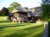
The aspect of Swampton as it stood at the time of the new distribution is discernible
in its present features. The houses were then all thatched, as many of them are now,
and frequently lie detached, and have a small outbuilding such as a barn, stable,
or granary adjoining, and behind all a strip of meadow land. If you survey the tithing
from a neighbouring elevation, it is striking how regular the small plots of pasture
are seen to extend in strips of different widths from the backs of the houses, each
one divided from the next by its neatly trimmed hedge, showing that at the time of
the allotments every villager was a small farmer. The allotment system brought to
an end a class, ranking above that of the labourer, and beneath that of the modern
farmer, who tilled their few acres of land, and kept their geese, pigs, and cows.
They were habited in the old British smock frock, and worked on the land themselves,
and were succeeded in their holdings by their sons, and they again by their children.
It was the period-
It is worthy of remark that of the allotees whose names appear on the map, the names of three only are now to be found in the parish of St. Mary Bourne, vizHoldway, Gale, and Wedge. And showing how in the course of a century land may change owners, not one of the allotments belongs at the present time to any member of the family of its original possessor, although the names of the original allotees still cling to some of the holdings.
The allottees represent the old forty shilling freeholders, who were the mass of the county voters previous to the passing of the Reform Bill of 1832. They were poor, and most of them mortgaged or sold their property, and became labourers. One remarkable character of this kind, living in Stoke tithing, I well remember, named Piper, who obtained a precarious livelihood by collecting wood ashes from the cottagers, which he sold to the better class farmers. It was his custom to traverse the parish every Monday with a string of donkeys, each bearing a bag to carry the ashes. (Dr. Joseph Stevens)